Mike Royden's Local History Pages
The Manor of Halewood
Moated Houses (II): Lovel's Hall and Yew Tree House
This article continues from Part I (Old Hutt) and looks at the sites of Lovel's Hall near Halebank, and Yew Tree House in Halewood. The former was manor house of Francis, Lord Lovel, aid to Richard III, who also fought at Bosworth, while Yew Tree House is a former hunting lodge of the Earls of Derby.
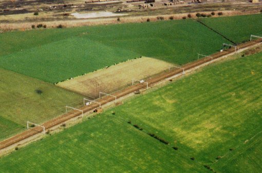
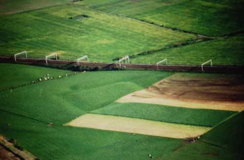
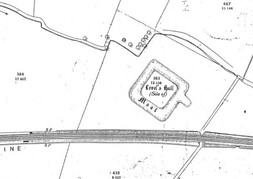
Lovel's Hall, has now completely disappeared, although the square 'platform' and the filled in moat can be clearly seen from the air. Situated north of Linner Farm at the Halebank end of the historical Township of Halewood, it was probably constructed by the Holland family in the mid 14th century.
The second Lord Holland died in 1373 and the land passed to his daughter Maud. Through her marriage to Sir John, Lord Lovel of Minster Lovel in Oxfordshire, ownership eventually passed to her great-great grandson, Francis, Lord Lovel (b.1456).
 Francis became a close friend and loyal supporter of Richard, Duke of Gloucester, who knighted Francis in 1481. Two years later, he was created Viscount Lovel by Edward IV. When Gloucester became King Richard III in 1483, he appointed Lovel later that same year to several offices, including that of Chief Butler of all England, Privy Chancellor, and Lord Chancellor of the Kings Household. In 1485 Sir Francis fought under Richard in the Kings' darkest hour, the Battle of Bosworth, where Richard was killed on the battlefield and the Crown taken by Henry VII. Francis had survived, but fled for his life.
After taking sanctuary in St.John's Abbey, Colchester, he led an unsuccessful revolt against Henry in 1486, before fleeing to the Furness Fells with other rebels. After a second failed uprising in June 1487 at Stoke-by-Newark, Lovel disappeared. Contemporary reports suggest he was killed on the battlefield, but they are by no means reliable. His name was later among a list of rebels offered asylum by James IV of Scotland, but there is no evidence that he ever went there.(1) It may have been a rouse to divert the attention of his enemies as to his true whereabouts.
What became of him is still a mystery to this day and as a consequence, several legends exist regarding his demise.(2) Edward Hall's Chronicle of 1542, for example, tells that he escaped from Stoke by attempting to cross the nearby River Trent at Fiskerton, but the bank was much too steep for his horse and they fell back in and drowned. This was a good tale to explain the lack of a body. Another story, once strongly believed by the people of Hale, was that once he had reached the opposite bank of the Mersey, near Runcorn, and on rushing to reach his house on the other side, he attempted to cross the river by the ancient ford, but was forced by the current towards Ince and was drowned. This is undoubtedly a corruption of the River Trent tale and must be discounted as local folklore.
 A third tale is rather more intriguing. Francis Bacon in his History of the Reign of King Henry VII also mentions that Lovel may have died in the battle, or drowned afterwards, but then adds that 'yet another report leaves him not there, but that he lived long after in a cave or vault'.(3)
Now in May 1708, almost a century after that document appeared, workmen were digging the foundations for a new chimney at Minster Lovel Hall. During the excavation they discovered an underground vault. Inside they found the skeleton of a man still seated at his desk on which was a book, paper and pen. Nearby was a cap, mouldy and decayed. Unfortunately, everything crumbled to dust soon after the fresh air was allowed inside.(4) But could this have been the vault mentioned by Bacon and the body of Sir Francis, who had died alone, still in fear of his life?
Officially, a court held just after his disappearance decided that he had escaped to the continent and had died at Flanders, but due to the lack of evidence we will probably never know what really happened.
Sadly, nothing is known of what his Hall looked like, although it was probably a substantial building. It is unlikely he ever resided there. His fortune and landholding was extensive as he held manorial land throughout the country, furthermore, the family base was still at Minster Lovel. He may have visited Halewood on occasions, but the Hall probably became so named due to his ancestor John Lovel's inheritance on marriage to Maud Holland, rather than Francis' occupancy.
A few months after Bosworth, Lovel was attainted and his lands were sequestrated. His land in Halewood was given to a loyal supporter of the new King, the first Earl of Derby, in whose hands it remained for several hundred years.
The Hall appears to have been the home demesne around which a medieval open field system of farming was arranged.(5) A study of field names, together with maps of the late 18th-mid 19th century, reveals a pattern of elongated fields which seem to have evolved from the piece- meal enclosure of furlong strips. Other features associated with the medieval open field arrangement may also be present, and in this respect, Cowell suggests evidence may exist of a former medieval park.(6)
A medieval park was an enclosed area, generally wooded, for the private use of the lord of the manor, in which animals were kept for hunting and to provide a constant supply of fresh meat. The bounds of the park were usually quite substantial, being banks with wooden fences known as pales and associated with ditches, to keep wild animals out and the deer within. The perimeters can often be recognised on the map by long continuous field boundaries, generally almost circular in shape, against which later field boundaries have been set.(7)
Early 14th century references are made to the park of Linnall in Hale, although the documents suggest that the park was located next to the township boundary of Ditton. Seventeenth century field-names called 'Linnow', adjacent to the open field area in Halewood, may represent the area of this former park. The name of Linner Farm, on Higher Lane (now Halebank Road) appears to be derived from 'Linnall'. Most of this former park area, which lay between Halebank and Ditton Brook, is now occupied by housing.
Near the north eastern boundary of the park, below the Ditton Brook bridge, are the occurrences of 'Peel' field names.(8) The element of 'Peel' frequently refers to a tower house or palisaded enclosure, but is often associated with moated sites. In this instance the proximity to the border of the park suggests that there may have been a Keeper's or hunting lodge situated there which could also have been moated.
The settlement nearby was not as concentrated as in the 'typical' appearances of medieval villages found further south. Nevertheless, three small nucleations were evident, all of whose inhabitants had shares in the open field system. Most central to the this system appeared to be a linear settlement on Higher Lane, south of Lovel's Hall, although this consisted of only three farms to the north of the road. Another small concentration occurred near the Halebank crossroads centred around the former village green (at the Potter's Lane/Hale Gate Road junction).
It is possible that this medieval settlement had decayed by the 18th century leaving just hints here and there of its former appearance. More field work and documentary work is needed to fully understand the developments.
4. Yew Tree House
 Today, Yew Tree House is a private dwelling situated in Almond Close, at the junction of Higher Road and Wood Road, near to Halewood Community Comprehensive School. Part of the house was built in the mid 17th century and may contain earlier fragments of a simple rectangular house of two rooms with a centre passage and a storey above. However, even this earlier structure is of a later date than the moat which once lay alongside.(1)
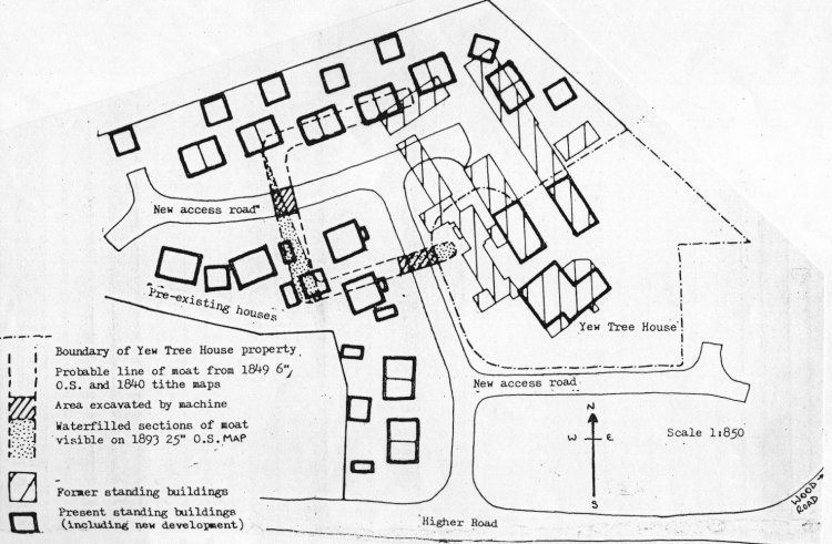
Although the area has been recorded on earlier maps(2) it was not until the Tithe Map of 1843 before a detailed survey was made of the site. A three sided moat was clearly evident in 1843, with part of the northern range of farm buildings encroaching over the eastern filled in section of the moat. In fact, the boundary lines running from the moat to the south towards Higher Road indicate the possibility of either a double moat or an extended rectangular platform. By the 1890's, only part of the moat's western section was visible, the remaining sides being filled in and enclosed. This small remaining section had disappeared by the mid 20th century.
The moated site has also been suggested as once being used as a hunting lodge by the Earl's of Derby.(3)Part of the Manor of Hale was placed by Henry II within a Royal Forest (which also included parts of Simonswood, Smithdown, Toxteth and Croxteth). This land, declared to lie between the Flaxpool to the Quintbridge, is thought to be the western area of Halewood(4) (the eastern end being the medieval open field arrangement discussed earlier). Halewood appears to have been disafforested by the end of the 14th century, and the use of Yew Tree by the Earl's of Derby was during a later period. Nevertheless, the site may have had its origin contemporary to the period of afforestation.
In 1974, plans were drawn to build new houses on part of the Yew Tree Farm estate, although planning permission was not given until 1976 (this estate was to become Broom Way and Almond Close). Realising that the destruction of an important medieval moated site was imminent, a party of volunteer diggers, mostly from the University of Liverpool Archaeological Society, arrived with precious little time available.(5) In fact, development had already commenced and any thoughts of excavating the platform had to be abandoned. This was a great pity as the site may have yielded much useful information about a type of site of which little is known in this area.(6)
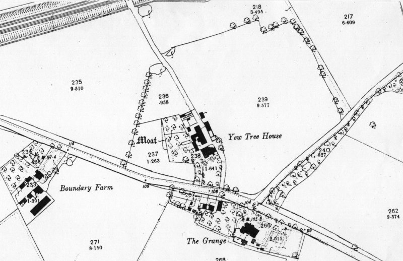 As it was too late to investigate the interior platform, work concentrated both on locating the northern section of the moat and on recording evidence from the trenches dug mechanically by the site developers. Sadly therefore, the team were denied the chance to seek an answer to the question as to whether or not a building had once existed on the site.
Regarding the moat, Margaret Warhurst reported, ... we located the north side of the moat and the approximate length, width and position of the north west corner. ... We still have no positive evidence for the exact position of the the east side of the moat...'.(7)
she concluded, '...We have no evidence for the use of the site, or of any buildings which might have been associated with it. From evidence found at similar sites in the North West we could expect the moat to have been dug originally in the 14th or 15th century, but we have no evidence for this site. The earliest material we found was some 16th century pottery.'(8)
The post medieval house built to the south east of the site (i.e. outside the moat - although part of the farm buildings lay over the filled-in eastern section) has changed its name several times; in 1783 it was known as Tarleton's House (after its owner Gilbert Tarleton); in 1843, Peacock House; 1848, Horrocks House; 1881, Peacock Farm; and from 1893, Yew Tree House.
The walls are of red sandstone with a slate roof. Stone mullioned windows, mostly of 4 lights, are still in existence with chamfered mullions also still exposed on an original rear wall. The interior has low ceiling beams in the earlier section of the house and a staircase possibly of the 18th century.
Gilbert Tarleton was probably responsible for the extension of the original post medieval structure, as additional wings were added c.1780 in red brick, with further additions in 1850 in similar fashion.
During the development of the site in 1976, several outbuildings of the farm were also destroyed leaving just Yew Tree House and two barns remaining from the former farm buildings. At the time of writing these barns are now undergoing modern conversion into dwellings, together with the addition of two modern houses close by.
The site has been closely monitored during the development, but so far little additional information has come to light.
5. Court Farm/Halewood Brewery Site
Finally, on the subject of moated sites, there is the possibility that the former Halewood Brewery at Court Farm to the rear of the Eagle and Child (off Church Road) was once erected on a moated site. Evidence is very scanty and much more work is required before a more reasonable claim can be made. At the time of writing the area was undergoing excavation. Hopefully this will shed further light on the history of the farm and brewery.
Footnotes
3. Lovel's Hall
1. O'Connor,S. 'Francis Lovel and the Rebels of Furness Fells', 'The Ricardian' (J.R.T.S.) Vol VII, no.96, (March 1987). pp.366-370.
2. For instance, debate rages among members of The Richard III Society. See Baldwin,D. 'What Happened to Lord Lovel' J.R.T.S., Vol VII, No.89, (June 1985) pp.56-65
3. Bacon,F. The History of the reign of King Henry the Seventh (1622), reprinted London 1971, p.67.
4. Detailed in a letter dated 9 August 1737, written by William Cowper 'clerk of the Parliament', to Francis Peck, the antiquary.
Cited in Baldwin op.cit. p.60
5. Despite aerial survey carried out by myself and also Dr. Robert Philpott of the M.A.S. (National Museums and Galleries on Merseyside), visible crop mark evidence is yet to be found. Nevertheless, Dr. Philpott has discovered strip field marks nearby in Hale.
6. Cowell,R. Knowsley Rural Fringes Survey, M.A.S., Merseyside County Museums, unpub. (1982) p.16-38
7. ibid. p.36
8. 'Peel Field' and 'Near Peel Field' - Halewood Tithe Map 1843.
4. Yew Tree House
1. M.C.M. Records File; Moated Sites of Lancashire no.81 Horrocks House
M.A.S. Records File; Knowsley Rural Fringes Survey records.
2. Earl of Derby Estate Map of Halewood (1783)
William Yates Map of Lancashire (1786)
Halewood Enclosure Map (1803) L.C.R.O. DDx/1171/1
3. Met. Bor. Knowsley. Listed Buildings Schedule 1977 (B3) Grade II listed 22.9.75. also in M.A.S. Survey Records File - Knowsley; Halewood Township ref. 4485/1
4. Farrer, op.cit. p. 141 and Cowell, Knowsley, p.28
5. It is significant to note that immediately after the conclusion of this excavation, a meeting of concerned professional and amateur archaeologists was held on the 25 March 1976. As a result the Merseyside Archaeological Society was launched and a Steering Committee formed, to act as a focal point for archaeological activities and to investigate and record threatened sites. Later that year consultations were held with other interested parties and the Society was officially inaugurated on 4 December 1976.
Morgan,D. 'Formation of the Merseyside Archaeological Society, J.M.A.S. vol 1 (1977) p. 3
6. ibid.
7. Warhurst, M. 'Moated Site at Halewood',J.M.A.S. vol 1 (1977) p.8
8. ibid.
Bibliography
Pye,E. The Village of Hale (1851)
Hale Hall with notes on the Family of Ireland-Blackburn(1881)
Payne-Gallwey,R. The Book of Duck Decoys (1886)
Beamont, W. Hale and Orford (1886)
Rylands, J.P. 'The Hutt in Halewood' The Old Halls of Lancashire and Cheshire, London (1893) pp.23-27
Irvine, W.F. 'The Origins of the Irelands of Hale', T.H.S.L.C., vol 16, (1900) p.139-146
Poole, C. Old Widnes and her Neighbourhood (1906)
Hand, C.R. The Old Hutte at Halewood, Liverpool (1914)
Hatton,P. The History of Hale (1968) (rev.ed.1991)
Warhurst, M. 'Moated Site at Halewood',Journal of the Merseyside Archaeological Society vol 1 (1977) pp 5-10
Hollinshead, J. Halewood Township During the First Quarter of the Eighteenth Century, M.Phil Thesis unpub, Liverpool University (1980)
vHollinshead, J. 'Halewood Township: A Community in the Early Eighteenth Century' T.H.S.L.C. vol 130 (1981)
Cowell,R. Knowsley Rural Fringes Survey, Merseyside County Museums- unpublished (1982)
Royden, M.W. The Effects of Enclosure: Halewood Township by the Mid Nineteenth Century, Liverpool University B.A. Thesis Unpub.(1989)
Royden,M.W. The Impact of the Coming of the Railway on Nineteenth Century Halewood, Liverpool University, B.A. Thesis Unpup.(1988) (copies held by Lp.R.O., Huyton & Halewood Libraries)
Wrathmell, S. 'Excavation and Survey at the Old Hutt, Halewood, in 1960', J.M.A.S. vol 8 1987 (pub. 1991)
Roberts,D. Research notes and photographs
Return to Home Page and Site Links
Articles Page