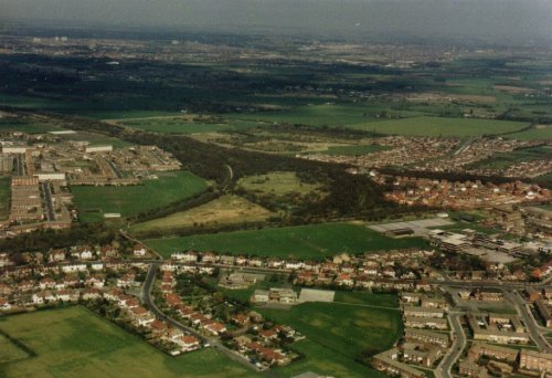
Halewood dissected by the Railway Triangle
Halewood dissected by the Railway Triangle
The nineteenth century township of Halewood with an acreage of 3,823(1), lay between the borders of Ditton Brook to the north, Rams Brook to the south and the Mersey shore as its third 'natural', eastern boundary. It was bounded on the west by a line running down Macketts Lane, continuing along the ancient Portway footpath to a point just south of the medieval moated house of Old Hutt where it joined Rams Brook. Halewood was situated on the south west lowlands of Lancashire and geographically was not particularly distinctive in the nineteenth century, the country being bare and flat with wide open fields, principally cultivated yielding crops of barley, oats, wheat, and root crops. The two main roads, Higher Lane and Lower Lane, ran loosely parallel from Macketts Lane on its western boundary, to Halebank in the east, being traversed by several smaller lanes along the route. In sharp contrast to its medieval past there were few trees, although the roads and most of the fields were bordered by substantial hawthorn hedgerows. On the Mersey Bank was a fringe of flat marshy fields and mud banks. There was no recognisable nucleus of settlement, rather a scattering of cottages throughout the township, although by the end of the century there were noticeable groupings at North End, Halewood Lane Ends (the 'village'), and Halebank.
The geological formation of the area is triassic with pebble beds of the bunter series in the eastern parts - a fault running from Halewood Lane Ends to the mouth of Rams Brook throws down these beds - and upper mottled sandstones of the same series predominant in the central western and northern areas.
Historical division of the township was evident for two reasons. Firstly the manor of Halewood which covered the larger section in the north and western areas, belonged to the Earl of Derby, whereas the smaller southern part was owned by the Ireland-Blackburne of Hale Manor. Secondly, ecclesiastical division existed in the sense that the north and western areas were the direct responsibility of Childwall parochial church and those in the south lay within the chapelry of Hale. Although a church was built as a chapel of ease at Halewood Village in 1839 the religious character of Halebank continued largely as before, especially after the erection of a Wesleyan chapel there in 1861.
The wood, from which the township derives its name, had been largely cleared by the sixteenth century, leaving only small isolated remnants of the medieval forest, such as Boars Wood. The mild climate together with reasonable soil provided a favourable basis for agriculture. The landscape featured large stone farm houses and out-buildings throughout the area. There was a brewery at Halewood Village, a workhouse nearby, four ale houses and three moated farm houses. By the mid nineteenth century, Halewood was still untouched by the industrial revolution which had transformed the neighbouring areas of Liverpool, St Helens, Widnes and Warrington.
Within a little over twenty years the township was to be dissected by three railway lines, also to have constructed three main line stations, main goods sidings, two small communities of railway cottages, and an iron foundry with its workers' cottages.
The foundation of these changes were laid by an Act of Parliament in 1846. The St. Helens Canal and Railway Company wishing to improve their Runcorn Gap railway (which had commenced operation in 1833) proposed, and received permission for, an extension up to the new dock at Garston. However, due to delays caused by lack of finance (especially during the Crimean War) and opposition from other railway companies, the line was not opened until 1 February 1858, when the Manchester, Sheffield and Lincolnshire Railway Company began running trains from Garston to Kings Cross via Warrington, Manchester and Sheffield. Passengers still had to travel between Garston and Liverpool City by road(2). The course of the railway through Halewood ran a fairly straight line from a point on the west boundary near Hollands House (formerly Halewood Manor House) to where Ditton Road crossed Ditton Brook. Stations were sited at Halebank Lane Ends (now Lower Road) and Ditton on the new bridge crossing the Brook. There were no significant cuttings or embankments.
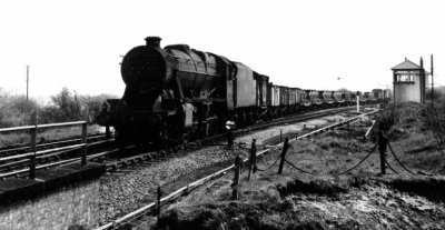
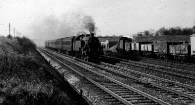
 late 19thc engine passing through the original Halewood Station
The second railway to pass through Halewood was constructed by a company that owed its origins to the intense competition between railway companies for the lucrative traffic to and from South Lancashire. Up to the mid century most of the Liverpool and Manchester trade was handled by the London and North Western Railway Company, who did not take kindly to the intrusion of other companies into their territories (of which the leasing of the St. Helens Canal and Railway Company line from Garston to Warrington by the MS and LR was a prime example). The LNWR began therefore to lease the St. Helens Line in 1860 and absorbed it by 1864. The rival companies began to look elsewhere for an alternative route and by combining the efforts and interests of the three major companies concerned, the MS and LR, the Great Northern Railway and the Midland Railway, they were able to amalgamate several small district railways and build further extensions until they could compete with the powerful LNWR in real terms. The first Act of Parliament dated 13 July 1863, called the 'Great Northern (Cheshire Lines) Act' gave the GNR and the MS and LR the power to operate those small independent railways. The 'Cheshire Lines Transfer Act' of 5 July 1865 was however, one of the most significant Acts in the history of the railways, for it grouped six railways together(3) making the MS and LR and GNR joint owners with the Midland Railway on equal partner by 18 July 1866. The Act of 6 July 1865 was,
'... to authorise the Manchester, Sheffield and Lincolnshire Railway Company to make a Railway to Liverpool and for other purposes....power to build on the lands depicted on the plans ... commencing in the Parish of Manchester in the County of Lancaster by a junction with the Manchester South Junction and Altrincham Railway and terminating in the parish of Childwall ... by a junction with the Garston and Liverpool Railway belonging to Manchester, Sheffield and Lincolnshire and Great Northern Railways ... Five years to complete from this Act ... Penalty for non-completion, �50 per day - the Company liable to the Crown' (4)
The Cheshire Lines Committee, as it was now known, opened the new Skelton Junction to Cressington Junction Line in 1873. Again, the course of the railway through Halewood was straight, entering the western boundary near the junction of Macketts Lane and Higher Road, moving eastwards, � mile north of the LNWR line and leaving the township � mile north of the LNWR at a point on the Ditton Brook near Yew Tree Farm, Lower Road. It had one station situated in Baileys Lane near the junction of Leathers Lane, which was opened for passengers in May 1873.
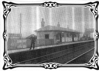 The original Halewood Station in Bailey's Lane
However, the efforts of the Cheshire Lines Committee were still insufficient with regard to the service to Liverpool docks, as it was found that their railheads at Garston and Brunswick were inadequate when compared to those of the LNWR and the Lancashire and Yorkshire Railway. Therefore after obtaining land at Huskisson (the north end of Liverpool docks) but having no access to it, an Act was granted in 1874 to construct a line from their Manchester line to the new dock, which would pass around the perimeter of Liverpool. They were to be known as the Liverpool North Extension Lines. The effect that this new project had on Halewood was that the southern connection was to meet the Manchester line at two points within the Halewood section. Three junctions were created in a triangular pattern(5) ; Hunts Cross East, Halewood East and Halewood North. The junctions and the line to Walton-on-the-Hill were opened on 1st December 1879 with the final extension to Huskisson opening on 1st June the following year. The enclosed land formed by the triangle of junctions was further utilised by the construction of sidings, which were opened in March 1881, Halewood West Junction being created in the process. They were to be used as a termination point for freight trains proceeding to and from Liverpool Docks (that is, Brunswick and Huskisson). Work went on into the mid eighties as the lines between Hunts Cross and Halewood East Junction were quadrupled to accommodate both freight and passenger services.

|
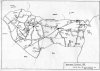
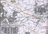
Local Railway Network (373k) |
|
Halewood, showing railway routes and stations (466k) |
Main Cheshire Line near the Triangle
Much of the material forming the embankments was taken from the tunnel excavations 'leading into Liverpool', and the sidings at the Triangle lie on ballast from Brunswick where solid sandstone rock had been blasted to make way for the new engine sheds.(9) It is likely that material from the Hunts Cross cutting was also used in the embankments. Posts and rails would mark the intended line of the railway. As the upper surface was carted away, a gullet would be excavated which would be just large enough to take a row of wagons. They were to be used to take earth away after being positioned alongside the navvies who would be working on the banks just above the temporary line. The gullet would be continued into the cutting while horse drawn trains of wagons would take the earth to the 'tip' at the end of the embankment. The excavation carved out by the navvies was done almost entirely by hand with pick and shovel. A timekeeper working for Brassey, the Railway pioneer, described a similar scene:
'I think as fine a spectacle as any man could witness, who is accustomed to look at work, is to see a cutting in full operation, with about twenty wagons being filled, every man at his post and every man with his shirt open, working in the heat of the day, the gangers looking about, and everything going like clockwork. Another thing that called forth remarks was the complete silence that prevailed among the men'(10)
The Poet Laureate John Masefield described, as a boy, his observations at an embankment site:
'The earthwork was manned by gangs of Public Works men who soon could be seen high up on the embankment top with trucks and horses working all day long at a game delightful to us to watch .... The loaded trolleys were drawn along the top of the work by clever horses which knew exactly, or were made exactly to stop and turn aside at the proper instant. The horse went aside, but the truck went on, and at the critical moment at the right spot, was checked and tipped with its tons of material. We could never see the device at work, but they delighted by their precision and skill...' (11)
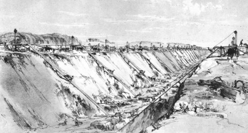
Children, and adults too, of rural Halewood were no doubt just as fascinated by these local intrusions. Navvies did not always work in the heat of day in this area however. Throughout the summer months of 1872 there were frequent problems with the effects of wet weather on the earthworks on the Liverpool extension at Halewood. In the Monthly Management Committee minutes of the Cheshire Lines Committee Railway were the following entries:
15.5.1872 - Liverpool Extension Rly. Most rapid progress, except earthwork at Halewood, which is affected by wet.
19.6.1872 - Very satisfactory progress. Halewood Bank being pushed on and stands well.
17.7.1872 - Great damage caused to works by a severe storm with a fury unprecedented.
21. 8.1872 - Only moderate progress owing to a vast deal of the country being under water.
16.10.1872 - Progress most satisfactorily in spite of a great deal of wet weather.
20.11.1872 - Halewood Bank closed 1st Nov, but a slip breached it on the 9th. Cuttings have suffered much from the wet
18.12.1872 - Poor progress owing to weather
15.1.1873 - Halewood Bank "now fairly settled." (12)
The extension was finally opened on 1st March 1873.
A division was becoming discernable in the morphology of the area by the early 1870's. The arrival of the railway and the building of the Iron Foundry created a settlement pattern centred around Halewood Village and Halewood Lane Ends, (mainly attracting railway workers) and Ditton Road/Foundry Lane, Halebank (attracting Foundry workers). In both areas workers' cottages were an added incentive in an area acutely short of housing. Railway cottages were built in Suttons Lane near the Triangle and on Lower Lane between 'The Heyes' farmhouse and the railway embankment. 'The Heyes' (13) was later taken over by the Cheshire Lines and converted into split accommodation for six workers' families, earning the nickname the 'Barracks'. In Halebank, workers' cottages sprang up along the old Bank End Lane (renamed Foundry Lane), Ditton Road, and a new industrial cottage community comprising of Johnson Street, Duke Street and Harrison Row.
|
Table 1: Population 1801-1901 |
INCREASE
| Date | Baptisms | Burials | Natural | Actual | Migration |
| 1841-51 | 168 | 25 | 143 | 45 | inconclusive(16) |
| 1851-61 | 252 | 47 | 205 | 59 | +149 |
| 1861-71 | 374 | 133 | 241 | 582 | +341 |
| 1871-81 | 425 | 194 | 231 | 70 | -161 |
| 1881-91 | 315 | 244 | 71 | 439 | +363 |
| 1891-1900 | 340 | 197 | 143 | -201 | -344 |
Returning to the period 1871-1881, evidence of poor trade and sickness in the area is found in the Annual District Medical Report of 1879:
'... HALEWOOD the part we had so much trouble with, has been very free from sickness of late: but we need not take all the praise for this as trade not having been so good here, many of the houses have not been occupied ...' (18)
The sickness was a severe epidemic of scarlet fever, mainly in the Ditton area, which was believed to have been contracted through washing laundry from Liverpool handled by local laundresses; two contributing factors to the decline in population in that period.
Analysis of birth places of the population in 1841 and 1881 goes some way to reveal the nature of migration into the township. Tables 3 and 4 show the totals taken from the census enumerators' books for those years.
TABLE 3: 1841
| Halewood | Halebank | Total | |
| Halewood & Rest of Lancs | 713 | 316 | 1029 |
| Rest of England | 38 | 18 | 56 |
| Ireland | 7 | 5 | 12 |
| Scotland | 4 | - | 4 |
| Total | 762 | 339 | 1101 |
TABLE 4: 1881
| Halewood | Halebank | Total | |
| Halewood | 418 | 397 | 815 |
| Rest of Lancs | 224 | 307 | 531 |
| Cheshire | 21 | 65 | 86 |
| Rest of England | 56 | 70 | 126 |
| Ireland | 37 | 83 | 120 |
| Scotland | 15 | 34 | 49 |
| Wales | 20 | 101 | 121 |
| Foreign | 4 | 5 | 9 |
| Total | 795 | 1062 | 1857 |
The census for 1841 is less detailed than those of later years, nevertheless trends can be noted. The totals in 1881 for the rest of Lancashire include great numbers from the surrounding countryside of Hale, Ditton, Speke and outer Liverpool. Significant migrations are those from Ireland and Wales. This was a trend found in many north-western areas - mainly urban industrial centres - much of the Irish migration taking place after the Potato Famine. The majority of the Welsh formed a labouring community in Halebank - most of the Irish and Welsh being unskilled, work at the Foundry was the major attraction. It must be remembered also that the area had a history of dissent and recusancy, (19) a fact which may well have further influenced settlement decisions. Table 5 shows what occupations were taken by the migrants in 1881.

The figures for agriculture include many workers from local areas who had moved into the area many years earlier, and also members of families whose heads had come to the township to work at the foundry or in other occupations generated by the railway. The combined total of railway and foundry workers (154) is clear evidence of the attraction to migrants.
The occupational structure for the whole of the township, irrespective of birthplace, changed noticeably between 1841 and 1881. (20) Study of Table 6 immediately reveals a drop in agricultural workers between 1871 and 1881 (which has already been discussed). Even though it is difficult to determine exactly how many agricultural workers there were in 1841, numbers did increase after that date. This may initially appear unusual, as the obvious move seems to be towards industry, however it must be remembered that a growing population, especially in the nearby industrial urban areas, has to be fed and this must have been a major contributing factor to that trend.
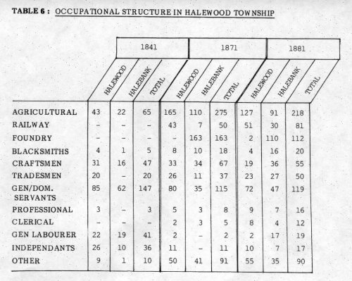
The unmistakable increase of course, took place in the numbers of railway and foundry workers by 1871. However, foundry workers had decreased by 1881 - more likely due to declining production now that much of the railway had been completed, rather than jobs lost through the introduction of more efficient machinery. Numbers of craftsmen had also tailed off by 1881. Many of these skilled workers were itinerant, moving on once the demand for their services, which had been generated by the arrival of the railway, had declined. In contrast, tradesmen maintained a steady increase. Their numbers included for example, shopkeepers, victuallers and publicans, whose services became established in a growing community with no reason to move on. This was more apparent in Halebank. Most of the women were employed either as servants or agricultural workers this did not change throughout the century.
 Towards Gateacre in Halewood Triangle West
Close analysis of the individual changes in Halewood and Halebank justifies their separation in this study. Practically all the differences in the calculated totals can be explained by the roles played by, and affected by the railways and the Iron Works in their respective locations.
One of the earliest effects the railway had in the area was that of the changes in land ownership. Once the Act of Parliament was passed to build the railway, three years were given for the compulsory purchase of required lands.(21) They were required however, to make known certain intentions:
'... The Company shall not less than eight weeks before they take in any Parish fifteen or more occupied houses either wholly or partially by persons belonging to the labouring classes as Tenants or Lodgers, make known their intention to take the same by Placards, Handbills or other general notice placed in Public view upon or within a reasonable distance from such houses: and the company shall not take any such houses until they have obtained the certificate of a Justice that it has been proved to his satisfaction that the company have made it known their intention to take the same in manner herein before required...' (22)
However, the railway planners were careful concerning their routes through Halewood, as no trace of the demolishing of houses has been found. The same could not be said for the effect on farm land. Northamptonshire landowners meeting at the White Horse, Towcester on 30th December 1830 considered the project for a railway from London to Birmingham and voiced their objections in the mood of the day. The railway would injure them:
1. By destroying the privacy and unity of the farms and cutting off part thereof from the homesteads.
2. By dividing into separate ill-shaped fragments closes which are now convenient in their form size and quality.
3. By occasioning deep cuttings across the slopes of hills and thereby intercepting the supply of water to the wells and grounds below them.
4. By occasioning large embankments across the low lands arid thereby intercepting the natural drainage of the parts above them.
5. By requiring in numerous cases so great a width for slopes in addition to that of the railway itself as to render any communication between the lands separated by it extremely difficult and inconvenient. (23)
Although this was written in 1830, much still applied to Halewood in 1858 and the 1870's. Item 1 certainly affected George Wright, the tenant farmer of Morris' Farm which was completely surrounded by the Triangle, the land dissected by each of the three lines. However, what compensation was to be paid, would be paid to the land owner which he was not. Nevertheless, his son William persevered with the farm even though his acreage had been reduced from forty eight to thirty one acres and he could only afford to retain one labourer instead of three as his father had done.
 Sidings at Halewood Triangle
On the question of land ownership and compensation, this effected almost exclusively only two landowners in Halewood: the Earl of Derby and Colonel John Ireland Blackburne (Lord of the Manor of Hale). (Unfortunately not all the Derby papers survive, and those that do only cover later smaller sales of lands for 'widenings' and 'easements' between the years 1864-1892 mainly in areas in North Liverpool. These sales alone amounted to �483,408). (24) Frequently, affected landowners were given shares in the new railway instead of cash compensation. In the census of 1881, 78 year old Ellen Bailey and her two sisters were living off such railway shares. The farm which she inherited from her father Thomas in Naylors Lane (now Baileys Lane), was encroached upon by the building of Halewood station and the approaches - the shares were received in exchange. In the same census, Helen Higginson, a 41 year old spinster, was also living off railway shares, at Derby Cottage in Church Road, although it is not certain how she came by them. Her home was also in the vicinity of the station and may have owned land taken by the railway.
However, most of the affected farmers were tenants who were not compensated and had to continue to make a living from reduced acreages, which were in many cases less accessible.
The physical appearance of the railway has already been discussed but the effect of its builders - the 'navvies' (25) - on the locality must have been marked. Not least by their appearance:
'... The dress too was distinctive. They wore moleskin trousers, double-canvas shirts, velveteen square-tailed coats, hobnail boots, gaudy handkerchiefs, and white felt hats with the brims turned up. They would pay fifteen shillings, a great price, for a sealskin cap, and their distinct badge was the rainbow waistcoat. They were often known to the contractor, and to everyone else, only by their nicknames - Gipsy Joe, Bellerophon, Fisherman, Fighting Jack ... they lodged when they could in villages and when there were no villages they herded into turf shanties... they were paid once a month, sometimes not so frequently, and usually in a public house, and then for days afterwards they drank their pay, sold their shovels for beer, rioted, and went on a randy...' (26)
We cannot be certain of course of the exact effect they did have on the township, nevertheless many itinerants did lodge in Halewood, mainly in the Village Baileys Lane area during the early 1870's, and no doubt brought many new images with them. One certainly recorded was their militancy:
'... The men at Halewood demanded an increase of wages, which the Contractors at once granted in order to avoid delay, "but, no sooner had the concession been fairly established that the men declined to fill more than 12 sets of wagons in place of 16 for a day's work." "As the men would not give way, others had to be obtained, which has caused delay, but one set is again thoroughly at work, and I trust that by the end of next week operations will be resumed at the ordinary speed....' 27
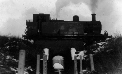 Halewood Triangle
Migrants who came looking for more permanent work must have had some measure of effect too. The two communities in 1841 had a migrant population of around 20%. By 1881 this had gone up to 49% in Halewood, and 62% in Halebank. Changes are fairly obvious, new houses and more shops for example. The transition in Halebank village area must have been quite striking. This sleepy, scattered rural community had now become a small concentrated industrial unit by 1881. (This must be kept in perspective however, such social changes were centred around the Halebank Road crossroads up to Ditton Station. Much of the surrounding lands have remained agricultural up to the present day). One idea that might have been new to Halebank people was the operation of a 'sick club'. Workers had little or no economic protection against ilIness as their employment was usually of the 'no work, no pay' variety. A club collector was at work in 1881 who would collect a regular donation from members and would pay them a subsistence when they were incapacitated. (28)
In the new dangers on the railway, rural folk soon became aware of the difference in being hit by a train than by a horse. Nine people buried in St. Nicholas' Churchyard between 1875 and 1888 suffered fatalities on the railways. (On the subject of burial records there was a noticeable attitude, hostile or otherwise, by the incumbent towards the railway. No causes of death are recorded throughout the burial registers of St.Nicholas except those on the railways - in fact, any relationship to the new railway was recorded:
'... of new Railway Cottages .... died at Railway Cottage.... wife of station master ....' and so on. Does this reflect a general feeling in the community, of hostility or awe, or just that of the presiding vicar? We cannot tell). One such fatality was recorded in the Huyton and Prescot Reporter of March 15th 1879, (29)
'An inquest was held at the Hunts Cross Hotel Much Woolton, before the deputy coroner, Mr Barker on Tuesday touching the death of John Thomas, a platelayer, 45 years of age, living at 10 Gladstone Road, Garston. Mr. J.E. Hanks watched the proceedings on behalf of the Cheshire Lines Committee. The deceased was one of a gang of men working on the Cheshire Lines Railway at Halewood on Saturday morning. He was standing in the four foot of the down line when his foreman shouted to him to get out of the way, as two trains were approaching in opposite directions. All the other men got out of the way except the deceased whose body was found after the trains had passed, lying in the six foot. His right hand was cut off, his left leg broken and the head very much crushed. Life was extinct. The jury returned a verdict of 'Accidental Death.'
Although the development of Halewood Township cannot be fully assessed in isolation, there was significant change in the community in the latter half of the nineteenth century even though it pales in comparison with changes taking place in Newton and Coppenhall. Nevertheless, we are concerned with transition within Halewood Township, and even though it was on a minor scale compared to certain areas, change within was relatively large. Factors governing the requirements for full industrial revolution have never been apparent in Halewood - indeed, once the wave of 'railway mania' in this area subsided, markets for the Iron Foundry could not be maintained, resulting in its decline and closure. Changes have been discussed in the area's geography, morphology, population, occupational structure and sociology. Mobility of the populace was increased; from the agricultural worker tied to the land who now saw new opportunities either in his own parish or distant urban centres, made more accessible by the railway; to the urban worker who could now commute from his home in the countryside (for example 39 year old Joseph Casson, a stock exchange cashier living in Woodside Cottage, Wood Road in 1881 who had moved there in 1875 less than a year after the opening of the station). Leisure time may also have changed, day excursions becoming available to places such as Southport and New Brighton (or even further afield for those who could afford it).
A rather abstract effect of the construction of the railway took place in Ditton in 1881. While sinking an artesian well approximately 200 yards from the station towards Liverpool, LNWR workers unearthed a 12th century medieval jug, but more spectacularly two Roman coins, one of Domitian A.D. 96 and one of Neva A.D. 98 which gave rise to many new theories regarding early settlement of the area.
|
Halewood - Modern O.S. Map (880k) |
However, many questions about the railway have not been treated here, as due to its confines, this study cannot purport to be comprehensive by any means. Nevertheless, the detail covered does give a measurement of insight into some of the effects the railway had on this small, scattered, rural community in the later nineteenth century.
Footnotes
1. Knowsley Record Office (Huyton Library Archive Department) Census 1881 Halewood Township.
2. The company also ran a steamer route from Garston to Liverpool but found this to be uneconomical and was discontinued in 1859.
3. The Stockport and Woodley Junction Railway
The Cheshire Midland Railway
The West Cheshire Railway
The Stockport, TImperley and Altrincham Junction Railway
The Garston and Liverpool Railway (Garston Junction to Brunswick Dock)
The Liverpool Central Station Railway (from near Brunswick to Central).
4. House of Commons Acts of Parliament 1865 - Liverpool Record Office.
5. The land enclosed by the lines and junctions is still known today as the 'Halewood Triangle'.
6. The updated Ordnance Survey one inch to one mile of this period clearly shows the Iron Works. It does not show the Runcorn Railway Bridge built by 1869. There are no records of men working in a Foundry in the Halebank Census of 1861 although by 1871 there were 163.
7. The Workhouse being sited at the village end of the lane near the modern day Crantock Close.
8. In the 1960's Wood Road was diverted yet again to meet Leathers Lane. Hollies Road continues the original route with a new stretch from the railway bridge to Wood Road.
9. R. Prys Griffiths, The Cheshire Lines Railway, (Oakwood, Hull 1947), p.1.
10. Arthur Helps - Life and Labours of Mr. Brassey (1872) - in this case cited in T. Coleman, The Railway Navvies, (London 1981), p.47.
11. John Masefield, Grace Before Ploughing, fragments of autobiography (Heinemann 1966), in this case Coleman, Ibid, pp.44-45.
12. Minutes of the Cheshire Lines Committee Railway Management Committee, Liverpool Record Office.
13. This is based on oral evidence from Messrs. Len Finch and Bob Copeland, former employees of Cheshire Lines, however, it is not clear precisely when this conversion took place. The farm was still in operation in 1881 according to the census, and maps of 1893 show the adjacent railway cottages still in use. The Heyes had been used in 1871 to house a Railway Contractor's family plus two other families of Railway workers and lodgers.
14. For the purpose of this analysis and those of the following sections the Township of Halewood has been split into two areas; Halewood and Halebank The boundary is that utilised by the census enumerators of the 19th century (Old Hutt and - Finch Lane end - Irelands Farm - Ditton Brook footbridge; see map). No discernable boundary actually existed, however, although one or two farms could be regarded as being with the Halewood District, the enumerators district is acceptably dose and more importantly, is consistent throughout the period. Therefore figures quoted are totals for these stipulated areas with a total for the Township where indicated.
15. A study of baptisms and burials for the first half of the century is difficult, as until 1839 (and later in the transition period) when Halewood Parish Church was built, inhabitants had to use Childwall Parish Church and in Halebank (where dissenters were also common) many used Hale Chapel of Ease.
16. 'Inconclusive' as a transition period for burials lasted for probably around twenty years after St. Nicholas was built, as older inhabitants would have been interred at Childwall. Baptisms however, settled down a little quicker. The migration total for 1851-61 is also too high for serious consideration.
17. Sources - Baptisms + Burials - St. Nicholas Parish Registers, Population Totals - Census Records - All at Knowsley Record Office.
18. Huyton and Prescot Reporter (8th March 1879), p.4, Knowsley Record Office.
19. A Wesleyan Chapel (later known as the Welsh Chapel) was built in Halebank in 1861.
20. Due to the lack of detail and accuracy in the 1841 census, many workers who were most likely agricultural labourers or 'farm servants' have been recorded as merely 'male servant' or 'female servant'. This must be borne in mind when comparing the 1841 totals of those respective groups. Although the percentage of domestic and general servants was high it was fairly unlikely to have exceeded that of agricultural workers in this area.
21. Act of Parliament Vict. Reg. 29. Liverpool Extension Act 1865 (16 July 1866), p.2634, Liverpool Record Office.
22. Ibid., p.2634.
23. Bucks. R.O. D/DU/615, in this case cited in J. Simmons, The Railway Town and Country 1830-1914', (London 1986), pp.300-301.
24. S.A. Moore, A Calendar of the Muniments of the Earl of Derby (1894) in this case cited in: John R. Kellett, Railways and Victorian Cities (London, 1979), p.179.
25. shortened and derived from 'Navigator', the term used to describe canal builders.
26. Coleman, Railway Navvies, p.28.
27. Minutes Cheshire Lines 20 March 1872, LP.R.O.
28. Census Enum. Books 1881, Knowsley R.O. Such a man was Hugh Shields a 25 year old Irish lodger at the home of an Irish Foundry worker, Dominick O1Donnell, in Johnson Street.
29. Knowsley Record Office.
30. Steel was also replacing Iron, especially in railway construction.
Primary Sources
Census Enumerator Books - Halewood (1841, 1851, 1861, 1871, 1881) - Knowsley R.O. (Microfilm).
Parish registers St. Nicholas Halewood - Knowsley R.O. ( Microfilm). Baptisms VOL.1.1830-1870 Burials VOL.1.1841-1897 VOL 2.1887-1892 VOL.2.18397-1902 VOL.3.1892-1902
Minutes of Cheshire Lines Committee Railway Management meetings - Lp.R.O.
Acts of Parliament (1845, 1865, 1866, 1883) - Lp. R.O.
House of Commons Committee report 27th March 1871 (Regarding Cheshire Lines Tunnelling Bill) - Liverpool R.O.
Huyton and Prescot reporter (Numerous editions, too many to detail but mainly between 1872-1880) - Knowsley R.O. (Microfilm).
1843 Halewood Tithe Assessment.
1843 Ordnance Survey of Halewood (6" to 1 mile). Ordnance Survey 25'1 to 1 mile series 1st edition:- Hale wood House + Higher Road Sheet 114/10; Surveyed 1891 (Pub. 1893) Old Hutt + Hale Road Sheet 114/14 Surveyed 1890 (Pub. 1893) North End + Village Sheet 114/6 Surveyed 1891 (Pub. 1:893) Lower Lane + Halebank Sheet 114/11 Surveyed 1890 (Pub. 1896) Ramsbrook Lane Sheet 114/15 Surveyed 1890 (Pub. 1893)
1783 Earl of Derby Halewood Estate Map.
1865-8 Ordnance Survey map of Merseyside.
(all maps and tithes from Lancashire R.O. Preston).
Oral evidence of Halewood residents, mainly Messrs. Len Finch and Bob Copeland, both former employees of Cheshire Lines and one time occupiers of Railway Cottages.
Secondary Sources - General
W. Farrer, ed. Victoria County History of Lancashire Vol.3 (1907).
C. Poole, Old Widnes and its Neighbourhood (1905).
F. Walker, Historical Geography of South West Lancashire before the Industrial Revolution, Transactions of the Chetham Society Vol. 103, 1939 (Manchester).
J.Hollingshead Halewood Township - A Community in the Early 18th Century, Transactions of the Historical Society of Lancashire and Cheshire Vol.130 1981 (Liverpool)
D.Mills, English Rural Communities (London 1973).
A. MacFarlane, Reconstructing Ristorical Communities (1977).
R.W. Cowell, Knowsley Rural Fringes Survey : Archaeological Survey of Merseyside (Merseyside County Museums 1982).
J.Eccles Centenary of Halewood Parish Church (Liverpool 1939).
Secondary sources - Railways
G.R. Hawke, Railways and Economic Growth in England and Wales 1840-1870 (London 1970).
J.R. Kellett, Railways and Victorian Cities (London 1979).
J. Simmons, The Railway in Town and Country 1330-1914 (London 1986).
H. Ellis, British Railway History 1830-1876 (London 1954).
T.E. Edwardes,ed. New Routes and Old Acres (Manchester 1902), (A comprebensive guidebook on the Cheshire Lines Committee Service).
R. Prys Griffiths, The Cheshire Lines Railway (Survey 1947).
T. Coleman, The Railway Navvies (London 1968).
B. Morgan, Railways Civil Engineering (Manchester 1973).
P. Norton, Waterways and Railways to Warrington, The Railway and Canal History Society 1974 (Surrey).
G. Holt, Regional History of the Railways of Great Britain Vol.10.
P Bolger, Illustrated History of Cheshire Lines (1984).
L.J. Smith, The Impact of the Liverpool and Manchester Railway on a South Lancashire Township: Newton-Le-Willows 1821-1851, T. H. S. L. C. Vol.129, 1979 (Liverpool).
 |
Return to Home Page and Site Links |
 |
Local History Contents Page |