Introduction
The twelfth century witnessed a rise in monasticism which saw increasing wealth and power achieved by the religious houses, mainly through gifts of land in alms made by the major landowners of England. Inevitably, much of the property was often situated great distances from the abbey. Such territory would be systematically exploited by the strategic location of monastic farms, usually known as granges, throughout these estates. Although no mother house was erected in Liverpool, there were numerous endowments of local property made to distant abbeys and priories such as Whalley, UpHolland and Cockersand. Rather than take a superficial look at a variety of holdings, we shall turn instead to pay close attention to two local granges in particular and follow the changes that affected both farms down to modern times.
Stanlawe Grange
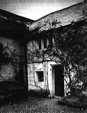
(right: Stanlawe Grange late 1800's: Front door of the main building, showing the mullioned window and the lower barn door to the left). (photo; Pinnington. Liverpool Record Office)
Stanlawe Grange still stands today, although much altered, tucked away among the leafy avenues and modern housing of Aigburth. There, sandwiched between a garden centre and a domineering Edwardian mansion, is this small sandstone structure, believed to date from the 13th century and reckoned to be the oldest building in the area. Stanlawe Grange was originally a medieval cruck frame building, although there has been continual alteration down the centuries. Recent work has been carried out with much sensitivity and the result is attractive, though giving little idea of the original date of the building. The oldest external evidence is a three-light mullioned window to the left of the front. In 1178,(1) following a gift from John de Lacy, Lord of Halton and Constable of Cheshire, the Cistercians founded an Abbey on the left bank of the River Mersey, between Eastham and Runcorn. It was situated at Stanlawe, the site of which now lies in isolated marsh-land above the oil refinery at Stanlow Point, cut off by the Manchester Ship Canal.(2) Benefactions increased during the next 50 years, which included land in Childwall and Aigburth. The 13th century Coucher Book of Whalley Abbey records that Adam de Gerstan, 'sold, demised, and confirmed to the Abbot and monks of Stanlawe, all his portion of land in Aikebergh, with common pasture in the township of Gerstan; also two bovates or oxgangs of land in Gerstan...'(3) Adam, lord of Garston, who died in 1265, was a great benefactor of religious houses and also gave land in Aigburth and Garston to Cockersand Abbey and the Knights of St. John.(4)
(left - Stanlawe Grange late 1800's: The Monk's Dwelling, with the Granary steps to the left. (photo; Pinnington. Liverpool Record Office)
The Grange for the monk's land in Aigburth comprised a detached Hall, barns, 'monk's quarters', and a granary. These outbuildings lay adjacent to the detached Hall in a square plan arrangement, open on the side that faced the Hall. They were situated either side and partly across the land used this century for the construction of the dual carriageway of Aigburth Hall Avenue, near to the junction of Aigburth Road. The farm was probably run by a Granger (or cellarer) who was given the authority of an Abbot. It is likely that he took up residence in the Hall, which became known as the Abbot's Grange. In the mid-19th century the field adjoining the Hall on the south east was still known as Little Grange Hey, while Great Grange Hey adjoined further to the east.(5)
It is unlikely that the Grange would have been occupied by monks, as their Rule was strict enough to prevent them working away from the Abbey and their daily communal service. Most likely, the estate was managed by lay-bretheren - the conversai - second class monks, who were illiterate and forbidden to aspire to full monastic status. Their role was to follow a simplified monastic regime and to see to the day to day running of their lands. This enabled the monks to give necessary priority to their religious obligations.
In the Ecclesiastical Taxation of 1291, it is recorded that the Grange at Aykebarwe, with half a ploughland, was worth 5s. a year. Assized rents brought in 12s. and the profit of the stock was 9s. 7d. These sums appear very small, but we do not know what allowances were made for the maintenance of the monks in charge.(6)
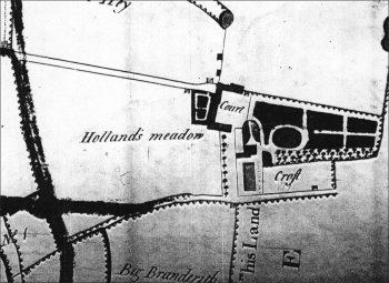
(right - Stanlawe Grange 1772: Plan of Stanlawe Grange included within an estate map of 1772 prepared for Thomas Beauclerk. The map shows the 'c' plan of the Grange buildings, Aigburth Hall to the immediate SW and the laid out gardens. (Liverpool Record Office).
Disputes over land were common. Important rights of pasturing cattle upon the wastes and of gathering turf for fuel were jealously preserved - any invasion across the border line was fiercely repelled. Inhabitants of Allerton Manor had frequent troubles of this kind '...with the powerful Lords of Speke and with the Granger of the Abbey of Stanlawe upon the River Mersey'. Furthermore, '...In 1253 Geoffrey de Chetham who had an interest in the Manor of Allerton a few years before, is found complaining that the monks had forcibly taken some of his turf and beaten his men...'(7) Such action, perhaps, of lay- bretheren, rather than their spiritual masters.
On the dissolution of the monasteries and the seizure of monastic lands by the Crown, Stanlawe Grange was leased to Lawrence Ireland for �4 a year and part of the estate awarded to the Savoy Hospital in London.(8) By 1550 it had passed by marriage into the Tarleton family of Fazakerley, who were to live at Aigburth for the next 130 years.(9)
The Tarletons were staunch Catholics and continued to practice their faith in an area noted for its widespread recusancy. The Upper Barn may well have been used for Mass during this era of religious persecution. It had a window of five-lights in the south-east end, which would have been invisible from the Liverpool road - which during the post medieval period terminated at the granary - and the stone steps leading up to it in the west corner would also have been screened from the road by the main granary building. Near the foot of these steps may have lain the graves of two priests, as in the old sandstone wall were carved the inscriptions: "+I.D.,1765" and "+I.B., I.H.S." (I.H.S. being the Society of Jesus). Priests could not be publicly buried in cemeteries, but only under cover of darkness in a secret spot. (In Lydiate and Windleshaw, this was achieved in or near a chapel). It may be that the "I.H.S." is actually "1715", in which case the "J.B." may be Joseph Berriman, a priest who died while working in Aigburth.
In 1593, Edward Tarleton, "the obstinate recusant" of Aigburth Hall, was being pursued by the sheriff of Liverpool, who led an unsuccessful raid on his home. The authorities were more successful with his son Edward who was convicted for recusancy in 1628 and had two thirds of his estate sequestrated as part of the punishment. In 1653 he was succeeded by his son Richard, who was to be the last Tarleton at Aigburth. His daughter and heiress, Dorothy, carried the estate in marriage to her husband John Harrington of Huyton Hall.
The Harringtons of Huyton, who were equally strong recusants, made Aigburth their principal home. John Harrington was one of the Lancashire recusants accused of planning a rising in favour of James II in 1690, and in 1701 Richard Norris, Mayor of Liverpool, was asked by the Government to keep a special watch on 'Mr. Harrington of Aigburth Hall' and 'Mr Blundell of Crosby', who were suspected of having been involved in Jacobite plots in 1694 and 1698. In 1720 John Harrington's son left the Aigburth estate to his brother-in-law, William Molyneux of Mossborough. Over the next hundred years the house passed through numerous hands until it fell into disrepair.(10)
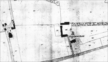 (left) Stanlawe Grange/Aigburth Hall 1845: Plan of Stanlawe Grange included within the Garston Tithe map of 1845. The map shows the 'c' plan of the Grange buildings and Aigburth Hall. The track that previously emerged from the monk's dwelling is now shown as a hedge/field boundary. The road at the bottom is Aigburth Road. (Liverpool Record Office).
By the 1840's, Aigburth Hall had been demolished and a new Hall built near the site, a little closer to Aigburth Road. In the late 19th century it was purchased by John A. Brodie, the City Engineer of Liverpool responsible for the construction of Aigburth Boulevard, Queens Drive and the proposer of the idea for a promenade from Dingle to Garston. The situation after the original Hall was demolished was described in A History of the Royal and Ancient Park of Toxteth,
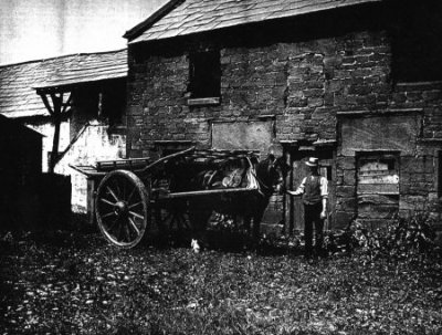
'...Most of the out buildings were left standing, added to, and improved, and still exist on the north west side of Aigburth Hall Road, which was afterwards constructed on this property. These buildings are the most conspicuous on Perry's Map (1768) where they form three sides of a square. Unfortunately, in the making of the garden city, one of these old barns, the nearest to Aigburth Road, was pulled down(11). That these old buildings was a place of considerable importance in bygone days is shown by the fact that as late as the date of this survey, the direct road from Liverpool terminated at the door of the cartway through the old granary, the main road to Garston being a loop road branching from this. An avenue of trees, probably oaks, is also shown on this map, leading back from the Garston Road to these old buildings. As late as 1810 the present road to Garston is called the 'New Road to Aigburth Hall'...'(12) By the turn of the 19th century, the Grange outbuildings had come into the ownership of James Pinnington, who made a careful photographic record of his home and locality.(13) The photographs also record the various stages of the demolition of the Lower Barn in February 1906, which preceded the construction of the new road.(14) Pinnington was responsible for the carving of the name 'Stanlawe Grange' into the sandstone wall on the left of the gateway in 1905.
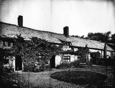
(right: Stanlawe Grange late 1800's - Main Building and quadrangle). (photo; Pinnington. Liverpool Record Office)
Together with the visual record we also have Griffiths description of the buildings made at the same time - a rare combination,
'...One glance at these old buildings is quite sufficient to impress the observer with their great age. The walls are built entirely of red sandstone,(15) each stone passing right through the wall to a depth of two feet. No mortar has been used, the stones being simply cemented together with red clay. A peculiarity of the architecture is the huge stones over the heads of the mullioned windows. The beams of the roof, which were once thatched, are all solid oak, worm-eaten and worn, but still as hard as iron, and have all been roughly shaped with an axe. Rough plates of oak are laid along the tops of the walls and to these are attached the oaken rafters; not a nail has been used, but the whole structure is compactly fastened together by means of oak pegs. Through one of the barns the open cartway runs. The ceiling of the passage is formed of young oak saplings split with an axe and covered over with a composition of red clay and chopped straw...'(16) Entrance to the granary was by means of fourteen stone steps, at the top of which was a massive oak door, studded with oak pegs and featured a medieval ring handle. Here again, no nail had been used in the construction. Griffiths noted,
'...A peculiarity of this specimen of the carpenter's craft is the manner in which the rugged boards are morticed together. These are not tongued and grooved as they would be in our day, but the V-shaped edge of one board fits into a corresponding hollow in the next one. The oak pegs are made secure by splitting the ends where they come through the inner side of the door and driving wedges therein. Entering the building, we are surrounded with a forest of oak purlin and age worn rafters. "What a quantity of oak there must have been in the district when this place was built", exclaimed a companion of the writer, who was standing by, thus unconsciously confirming the age of the structure and the derivation of the name "Ackebergh"; 'the place of many oaks'.(17)
In the Monk's Dwelling was a centre window. The two original doors surmounted by their massive stone lintels had been built up, and another doorway within recent years had been made between them. Dripstones had been carried over the doors and mullioned windows placed across almost the entire front of the building. The construction of the upper floor was similar to that of the barns and granary. The loft above and the ceiling of the open cartway at the eastern end of the main building were formed entirely of oak saplings roughly split with an axe and firmly cemented together with wattle- and-daub. At the south end of the eastern wing (which was demolished in 1913) was a fine, five light mullioned window, and the barns forming both wings were studded with embrasures, narrowing to a mere slit on the outer sides of their massive walls. There was evidence that the Barns had been shortened on the construction of Aigburth Hall Road in 1820-22. It was also apparent that several of the doorways had been built up over the course of years, the principal one having been at the top of the stone steps and at right angles to the original door.
Robert Griffiths had observed the destruction of the Lower Barn and expressed concern over the plans to demolish further buildings. Appalled at how the speed of suburban sprawl was swallowing up local sites of historical interest, he was concerned that the Grange would not be despatched in similar manner,
'...The ancient buildings of the district are few; in fact, we doubt if it is possible to find another so old for ten miles around...The principal building is well nigh one hundred feet long, and offers a fine opportunity for the formation of a local museum and library for the neighbourhood...'(18) Griffiths even ventured to suggest a list of suitable exhibits. His pleas however, fell on deaf ears, and in 1913 the Upper Barn was demolished to enable the road alterations to be carried out. In 1934, Aigburth Hall and estate was sold to Tallis Estates Limited. Overlooking the Cricket Ground and surrounded by attractive spacious gardens and lawns, the new owners demolished the Hall and erected around 20 semi-detached houses, although their proposal to erect shops on the plot fronting Aigburth Road did not see the light of day. In 1962 'Nos.3 and 3a Aigburth Hall Avenue', which was formerly the 'Monks Dwelling House' were put up for auction. At that time they were being used as stores and offices.
Today what remains of the Grange outbuildings bear little resemblance even to the remaining structures of the first years of this century. Stanlawe Grange presently comprises the former Main Building, the Granary and the Monks Dwelling House, (that is, the section that once linked the two barns) which have now been re-modernised into two dwellings. The mullioned window on the left front is one of the few external indications of the building's former antiquity. It now has Grade II listed building status and further alterations are very closely monitored.
Garston Hall
 Garston Hall was a half timbered building situated on a rocky promontory and once formed a picturesque scene as it stood overhanging the lower mill dam of Garston Dale. During the medieval period the Hall was a monastic grange, held by the Benedictine monks of the Priory of St. Thomas the Martyr of Upholland who were permitted to collect the tithes.(19)
The links with UpHolland are confirmed by a decree made in 1334, by Roger, Bishop of Lichfield, directing that Brother William of Doncaster, who was formerly a Prior, was residing alone in the 'manor house at Garston, contrary to the Rule and to good order'. The Bishop commanded that the monks recall him to UpHolland at once, under the threat of excommunication. It would appear that ex-Prior William had quarrelled with his monastic brethren, and they had sent him away to Garston for the sake of peace. William returned to UpHolland at a much reduced rank.(20) A few years later, John the Prior of UpHolland, appeared in court in 1350 against Nicholas de Bold and others who were accused of stealing goods and chattels valued at 100 shillings from monastic land at Woolton and from 'his fold at Garston'.(21)
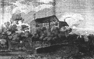
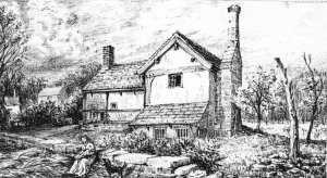
(left) (Drawn by N.G.Philips, pub.1822) Contemporary prints and maps clearly show the Hall. A useful drawing was made in 1822 by N.G. Phillips for his book 'Views of the Old Halls of Lancashire and Cheshire (1893)', which shows the Hall from Garston Bridge below, with the Mill Pool on the left. In 1889, Edward Cox made several drawings of Garston village, although some hark back to an earlier period; these appear to have been based on his own recollections. One drawing is from a similar vantage point to that of Phillips. Another, specifically featuring the Hall, appears to have been drawn from the south showing the remains of an enclosure wall in the foreground (-above).
The hall has been approximately dated to c.1480,(22) although it may have replaced an earlier building. The building faced south and consisted of a centre structure with two cross wings arranged in an H- shaped ground plan. The wings were gabled at each end and a large octagonal chimney shaft rose in the centre of the west wing. The remains of a strong walled enclosure with a ditch, apparently much older than the Hall, surrounded the house, and one of its lines continued as a boundary to the field above the lower mill dam which was known as the Monk's Field. (The Monks Field, or Meadow, was once at the corner of Garston Old Road and Church Road opposite to the end of Speke Road. The site is now occupied by a fork in the railway line and the junction of St. Mary's road).
After the dissolution, Garston became the property first of the Duchy of Lancaster, and then of the Bishops of Chester, but it was leased successively to two recusant families, the Andertons and the Gerards. In the lists of Lands of the Dissolved Religious Houses (1536-7) the following entry appears under the Priory of (Up) Holland,
'Chyldewall rectory: Farm of Grastan Hall in Garston and a pasture called Pryors Heys in Hale, parcels of the Glebe lands of Chyldewall.
Farms of the tithebarns of Garston and Agburgh, Lee Barne, Wotton Barne, Lytle Barne of the Grene, Hale Barne, Banke Barn alias Hale Bank Barne and Wavertre Barne with the Tithes of corn belonging to them and tithes of corn in Speke, corn and hay in Thyngwall, hay in Garstan Hall and hay in Chyldewall not before mentioned. Tithes of wool and lambs'(24)
and in Lancashire Papist Estates (1717) the lands held by Sir William Gerard of Garswood, were described as,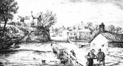
(right - Garston Village as it was in 1850. (Drawn by Edward Cox in 1884) The hall stands on top of the rock to the left, with the village cross at the bottom of the steps). (Source: 'Account of Garston etc. T.H.S.L.C vol 40 1888 (N.S. vol 4) pp.121-143).
'In the Parish of Childwall; The Rectory, Parsonage, and Parish Church of Childwall, Parcell of the Dissolved Priory of Saint Thomas the Martyr in Holland, now parcell and annexed to the Bishop of Chester, the tithebarns called the Tythbarns of Garston, Lee, and Woolton, the soil and site thereof or where the same are or lately stood...Messuage in Garston, parcel of the said Rectory, called Garston Hall, and closes called the Fold, the Two Gardens, the Bleaching Yard, th Orchard, the Hemp Yard, and the Further Orchard, and all the appurtenances of the Rectory, excepting the Advowson...'(25) According to Edward Cox, there was a local tradition, widely believed in last century, that a room in Garston Hall was once used as a Roman Catholic Chapel, of which he could find no trace at the time of his research. This room may have been in the east wing however, which had long since perished by his time. The existence of a chapel would hardly be surprising, taking into account the widespread religious deviance in the locality. Successive generations occupying Stanlawe Grange, for example, persisted in clandestine worship, as did those at Speke Hall.
Indeed, there seemed to be few, if any, Protestants in the village of Garston. The ancient chapel of St. Wilfred, which had been confiscated as a chantry under Edward VI, was used only as a rent-receiving centre, rather than for Protestant worship. The village also produced several priests, who were smuggled abroad for their studies and ordination before returning for a life of service and as a hunted missionary. Three priests came from the Garston Chaloner family alone, and a daughter Helen was imprisoned for several years under Queen Elizabeth for harbouring such a priest - a crime for which saw a number of women hanged.

(left) Garston Tithe Map (Extract) 1848 Garston Hall is the large building in the centre of the map above plot 293.
Below the Hall was the Mill Dam. The pool was fed by two springs, one of which rose in the Camp Hill area of Woolton and other near Elm Hall in Allerton. The latter brook crossed Rose Lane and Pitville, and can be traced on 19th century maps where it ran parallel to Melbreck Road before passing under a bridge at the foot of Greenhill Road (where the road turns at the Heath public house). It then passed 'Brook Cottage' where Allerton Station now stands and curved around the contour before entering the upper dam pool behind the site now occupied by Garston Baths. This pool was dammed at the foot of what is now St. Mary's Road. Over the dam was 'Garston Bridge' and below was the Lower Mill Pool. This Pool ran parallel with Church road before continuing as a brook into a third dam. The outlet ran into the Mersey where the southern Garston dock is now situated. In October 1982, during the construction of the Garston by-pass, engineers uncovered a section of the culvert and the course of this brook which once fed the mill pools. The remains were recorded by Garston Historical Society before re-sealing.
During the excavation for the new dock c.1869, an unusual reminder of the religious ritual performed by the flagellant monks was recovered from ten feet below the surface (pictured below right). It was an iron-linked flagellum consisting of seven chains, each chain having seven links connected by stars and weighing 17� ounces. This was a 'scourge' which a monk would use on himself while reciting the seven penitential psalms. A very severe instrument, the links were fitted with spikes instead of the usual seven leather thongs or cords.
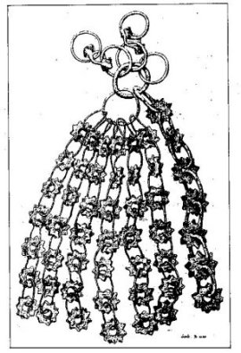 Its discovery caused great interest and was reported in the Journal of the British Archaeological Association of 1870. It was considered to be 'of the finest, most perfect and curious examples of its kind', especially as it had escaped destruction from rust, and was estimated to be of 15th century origin. The object was in the possession of Mr. G. Sinclair-Robertson of New Brighton in 1870, although today its whereabouts are unknown.(26)
Just below the Hall, on the bank of the Dam pool on the present site of St. Mary's road and Church Road, stood the village cross, although even in its original position it had been reduced to a stump. In the base were sockets for stocks. During the redevelopment of the area it was removed, eventually being re-sited in the grounds of St. Francis of Assisi Church in nearby Earp Street.
(left - Garston Village Cross (Drawn by Edward Cox in 1884) Formerly at the head of the Mill Dam, the stump has now been relocated into the churchyard of St.Francis in Earp Street. (Source: 'Account of Garston etc. T.H.S.L.C vol 40 1888 (N.S. vol 4) pp.121-143).
Garston Hall, meanwhile, was finally demolished during the late 1880's. The Garston Empire was later erected on the site destroying all traces of the Hall's existence.
The scene of the mill pool and the narrow dingle leading to the Mersey has, of course, changed beyond all recognition from the image described by Edward Cox. The industrial and urban growth which had its roots in the late 19th century, conspired to remove all traces of the Dale of Garston. The railway company's search for a suitable access point to the south docks sparked off a marked increase in the industrial development of the area. Yet the presence of industry was nothing new to this narrow gorge. When Adam de Gerstan gave permission to the monks for the erecting of a tanning or fulling mill in the Dale, it was reputed to be the first mill in Lancashire to be erected for manufacturing purposes.(27) Below the mill pool the villagers operated a fishery (see chapter 7) but the enterprise was curtailed at the end of the 18th century when a vitriol works was erected on the site now occupied partly by the south dock. In the early 1790's John Blackburne(28) transferred his saltworks to that site from Liverpool. The Vitriol Works were closed in 1798 and the announcement carried in the local press regarding the sale also described the accompanying estate;
'...an excellent house, lately built, and a good garden, suitable for the Manager or Director, and upwards of 5 acres of good land of large measure, with a great number of beautiful oak and other trees, the whole forming that beautiful spot, well known as Garston Mill Dale'.(29) Despite the industrial continuity, the view from Garston Hall must still have been quite beautiful - the image of a thriving fishing hamlet with a couple of water mills seems much more attractive somehow than the gasworks.
Footnotes
1. There is a dispute over the actual year - various dates are given by chroniclers of 1163, 1172 and 1173. The date of 1178 comes from Leycester's Hist. Ant. (1673)
2. The site was a poor choice as the low lying marsh was liable to flooding by the Mersey. The monks suffered such action in 1279, the tower of the church was blown down in 1287, and a fire and
further flooding occurred two years later. By 1296 they had moved to Whalley in Ribblesdale.
3. The Coucher Book of Whalley Abbey, extract translated from the Latin in Boult, J. 'The Historical Topography of Aigburth and Garston', T.H.S.L.C. vol 20 (1868), p.149.
4. VCH p.122/3
5. Garston Tithe Map 1841, L.C.R.O. ref DRL/1/28; Field no.360 is Little Grange Hey and No. 357 is Great Grange Hey.
6. VCH p.125.
7. Stewart-Brown, R. A History of the Manor and Township of Allerton (1911) p.219
8. Lumby,J. 'The Norris Deeds', Chetham Society Vol. 9, (1939) pp.230-2 and Boult, op.cit.
9. The Grange was now known as Aigburth Hall, not to be confused with Aigburth Old Hall, situated near the junction of the modern Mersey Road and Aigburth Road, thought to be the site of the Lords of Garston and Aigburth.
10. More detailed accounts can be found in VCH p.127, Boult p.181-9
11. The Lower Barn.
12. Griffiths, R. A History of the Royal and Ancient Park of Toxteth (1907) pp.139-40.
13. A series of 102 black & white photographs, taken between 1883 and 1906, mounted, captioned and boxed, now reside in Lp.R.O., of which 64 cover Stanlawe Grange.
14. Aigburth Hall Road had been cut during the early 19th century. The demolition of the Barns would enable it to be widened and renamed Aigburth Hall Avenue.
15. It is most likely that the materials came from the nearby sandstone quarry situated approximately on the site now occupied by the junction of the modern Rockside Road and Cooper Avenue North. (Noted on 6" to 1 mile O.S. Map 1849)
16. Griffiths, op.cit. p.140-142
17. ibid. p.142
18. ibid. p.143
19. VCH p.125
20. ibid., p.125
21. ibid.
22. Cox, E.W. 'Some Account of Garston, and of the Ancient Chapel of St. Michael formerly existing there', T.H.S.L.C. vol.40 (New Series Vol.4) (1888). p.136
23. Coucher Book of Whalley Abbey (c.1293), this extract translated in Boult, J. op.cit. p.152
24. Lands of the Dissolved Religious Houses, P.R.O. Lists and Indexes series no.3 vols 1-7, No. 214 D.L. no. 2304 (27-28 Hen.VIII 1536- 7) p.46
25. France, (ed.), Lancashire Papist Estates 1717, (1960)
An advowson is the right to present a clergyman to a benefice, usually subject to the approval of the diocesan bishop.
26. 'A Penitential Scourge For Garston', T.H.S.L.C. vol __ (1870) pp.___-__, also in the Journal of the British Archaeological Association 11 Jan 1870.
27. Boult, op.cit. p.155
28. John Blackburne was a nephew of the Thomas Blackburne who married into the Irelands of Hale. He was mayor of Liverpool in 1788 and lived at Blackburne House in Hope Street and Wavertree Hall in Church Road.
29. Gore's General Advertiser September 1799.
Bibliography
Boult, J. 'The Historical Topography of Aigburth and Garston', T.H.S.L.C. vol 20 (1868) (includes relevant translated extracts from the latin 'Coucher Book of Whalley Abbey' (c.1296) Chetham Society).
Cox, E.W. 'Some Account of Garston, and of the Ancient Chapel of St. Michael formerly existing there', T.H.S.L.C. vol.40 (New Series Vol.4) (1888).
Griffiths, R. The History of the Royal and Ancient Park of Toxteth (1907)
Hand, C.R. 'Stanlawe Grange at Aigburth', T.H.S.L.C., vol.71 (n.s.35) (1919)
Saunders-Jones, Leaves from My Note Book: Interesting Items concerning the Ancient Historic District of Garston, Liverpool (1926)
Stonor, J. Liverpool's Hidden Story, Liverpool (1957)
Swift, J.M. The Story of Garston and its Church Liverpool (1937)
Deposited at Liverpool R.O.:
Pinnington, J. Photographs of Aigburth 1873-1906 (102 photographs including extensive coverage of Stanlawe Grange taken by this former occupant).
Waite, J. Historic Houses of Liverpool 1888-1921 (3 volumes of photographs - vol 1. covers Aigburth)
 |
Return to Home Page and Site Links |
|
Articles Page |