 In all of recorded early history, it would appear that only during the Roman occupation had there been any properly conducted building programme of designed, engineered, and paved roads. But with the departure of the Romans - their empire imploding around the Fifth Century - the highway network was neglected and fell into disrepair, as the country entered into the Dark Ages. Their legacy of a basic system of roadways was, in the main lost, as all of England suffered invasion from rival tribes from Scandinavia and Northern Europe.
Subsequently England degenerated into minor Kingdoms, whose inhabitants relied on self-sufficiency, and who came to view contact with neighbouring populations as potentially dangerous. Such roads that the Romans had left then served no major purpose, and as a result they crumbled and fell into disrepair. It may be a fair assumption that in various places, the very stone and rock which was the road content, could well, over a long period have been plundered to provide a ready source of building material for houses, manors, or castles. As, over the following centuries, England eventually recovered and unified into a single nation, the local pathways and lanes between centres of population initially only served for allowing access to local markets, and the use of drovers, pilgrims, etc.
At the beginning of the Eighteenth Century, this was the picture. The highways of England consisted of these unmetalled tracks and lanes, which had connected hamlets, villages and towns since virtually the Dark Ages. But now there was a rapidly increasing population, and large towns were beginning to develop, there was an ever-increasing demand for produce of all sorts to be transported on a regular basis, between towns and villages. It became obvious that the highways as they existed, could not accommodate the literally vastly increased loads being placed upon them.
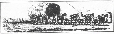
(right: Liverpool and London stage wagon (Liverpool Public Library. Binns Coll. Vol 10 p. 141)
Legislation had in fact been put in place as long ago as 1555, in order to allow for parishes to maintain all road within their boundaries.
'Surveyors appointed by the churchwardens were meant to supervise parishioners who were obliged to work for four - and from 1563 - for six days per year on maintaining roads. However, both surveyors and parishioners were often reluctant to do their work, being virtual conscripts. Local justices could supplement the statute labour by levying a rate on the parish, but neither part of the system worked well, particularly on main roads.'
The reality was that everyone used them, although nobody made provision for funding to maintain or repair existing roads, nor did anyone make plans to finance the layout of new ones. Some means of efficient funding simply had to be found to facilitate the increasing volume of traffic and communication between towns and cities.
Solution was found in proposals for the establishment of a Turnpike system, by which the revenue was to be raised by levy of a toll on those who used the highways. As long ago as 1663 precedent had already been set, with regard to tolls. In that year, part of the Great North Road out of London was taxed using this method. So the concept was certainly not new, but earlier application had apparently been piecemeal and random. So acute was the problem now though, that the new proposals were meant to be serious, comprehensive, and eventually address the problem of all significant routes across the land. Regional legislation was to be initiated by way of locally generated petition to Parliament. By this method, it was enshrined in law, and subsequently introduced across the nation in a series of Acts.
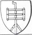
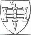
Turnstile (left), Turnpike (right)
Heraldic representation of tunrnpike and turnstile (Coppinger's Heraldry Simplified.
'An early Turnpike Act was passed in 1706 and concerned a stretch of road between Farnhill in Bedfordshire and Stony Stratford. By 1770 around 500 Trusts were controlling 15,000 miles of road, and by 1836 1,000 Trusts were charging for the use of 22,000 miles of road. Most bars became free of toll in 1895, although a few private roads remained open until the 1930s.'
Needless to say, Roby, with its geographical position, between the growing port of Liverpool, the outlying towns, and the neighbouring manufacturing centre of Manchester, found itself playing a pivotal role at the centre of a road revolution which was having a profound effect on transport and communication.
The employment of simple barriers to deny access, was the crux of the turnpike system.
'The word 'turnpike', which was soon applied to the road itself, originally referred to the barrier placed across the road, a cross-bar pivoted on a central post. More often, a conventional gate would have been used, but the name stuck.'
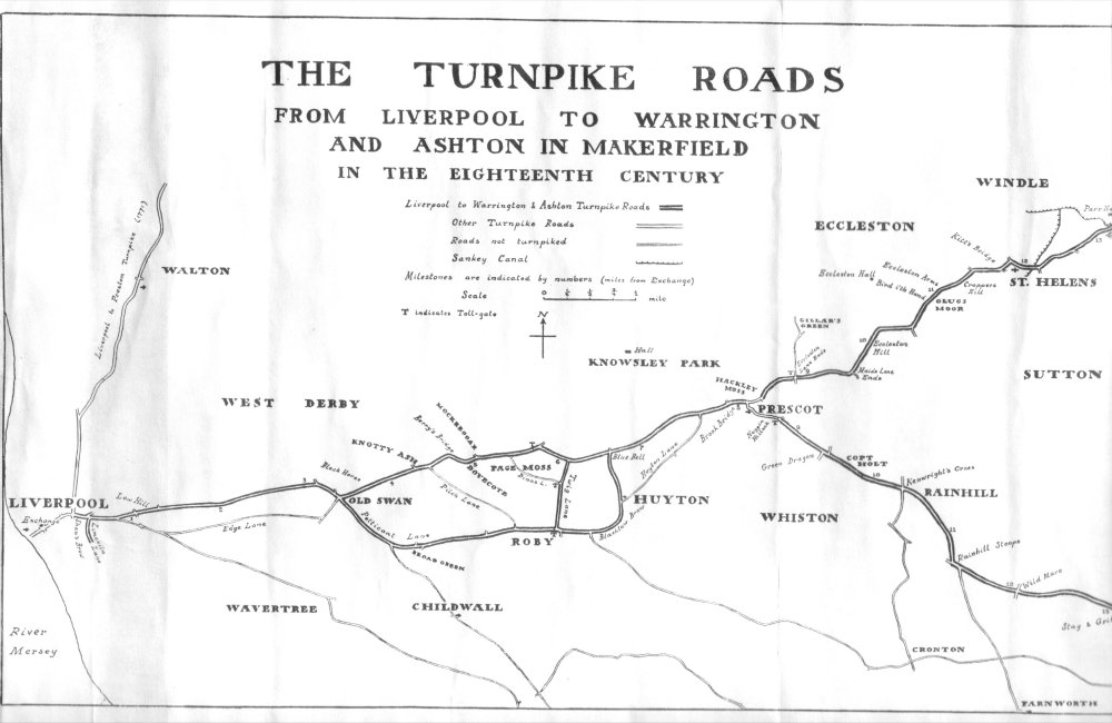
Much information about the Act can be gleaned from the 'Minutes of the Trustees of the Turnpike Roads from Liverpool to Prescot, St.Helens, Warrington and Ashton in Makerfield; 1726-89'. These were reprinted from 'The Transactions of the Historic Society of Lancashire and Cheshire. Vol.89 (1937).' And they state:
'The reasons for the creation of this turnpike are revealed in the Liverpool 'Town Books', the House of Commons 'Journals', and the preamble to the Act of 1726. In November of 1725 an order was made by the Common Council of Liverpool, as follows:
The Act proved effective towards raising the necessary revenue and in all it was renewed a total of three more times - in 1746, 1753, and 1802. Each Act renewal refined the administration of, and allowed for alterations to the roadway system. But the detailed decisions which involved allowing for construction of the necessary infrastructure, in the form of gates and toll lodges etc. was taken over, and through, a series of trustee's meetings. Click for enlarged map
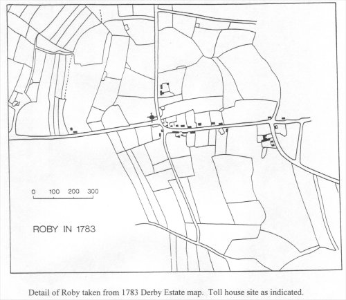
At a meeting on 1st July 1726, the decision was made to set up two turnpikes. One was to be on the main Prescot Road "at or about Whiteside's or Lurdy's Lane End". This gate, by the side of the Eagle and Child Hotel, was originally known as the Prescot Gate before 1753, but became more familiarly the Huyton Gate after that date when there was in fact a gate set up in Prescot. The other gate would be erected on the Roby road "at or about the End of Widow Price's Barn at Roby Town End". The Roby Gate was where a Toll Gate Lodge - which we are familiar with, and exists today - was sited. To prevent unauthorised usage of the system, a 'Stop Gate' was set up 'across the Lane end leading out of Twigg Lane over Page Moss" (this would be Dinas Lane). Apparently this was very effective, and wasn't subsequently altered. However, the minutes do say that with regard to the people, who lived in the area, "There were about five miles of road on the Liverpool side of Huyton, which could be used gratis"
Such was the urgency for a solution to their transport problems, that no sooner had the Act of 1726 been passed, than construction work commenced.
Click for enlarged map
From the wording relating to the Act of 1746, we can gather that there must have been more than a little prior discussion relating to the level of tolls. The Trustees had the power to vary the rates of toll, and this is reflected in the revised regulations.
'Chariots, and also upon Carts and Carriages carrying Earthen Ware, Glass and Cast Iron'.... Whereas complaints have been made, that the Tolls and Duties laid upon Coaches and, by the said former Act (the one of 1726), have been burdensome...' and lays down revised tolls: 'for each and every Horse, Mare, or Gelding, drawing any Coach, Chariot, Landau, Berlin, Calash, Hearse, Chaise and Chair, the Sum of One Penny. And for every Cart or Carriage (other than Waggons) laden with, or carrying Earthen Ware, Glass, Iron, or other Goods, and drawn by Six Horses, or other Cattle, the Sum of Six Pence: and drawn by Five Horses, or other Cattle, Five Pence' and so on, down to one horse, one penny. 'And for every Horse, Mare, Mule, Ass, or other Cattle, One Halfpenny'
The interests of the local nobility, gentry and manufacturers are clearly represented in the concessions granted to coaches and 'chariots', and to carriers of earthenware, glass and cast iron, though it is curious that the carriage of coal, usually said to be the reason for the creation of the turnpike trust, is not mentioned. Perhaps the carriers of coal were a captive market and so did not qualify for concessions.' (King, ibid.)
Besides the increase in commercial traffic, due to the growth of population and trade, it is evident that the road network was beginning to assume a national and strategic importance from a political and military standpoint. The requirement to be able to transport vital materials rapidly, in quantity and in all weather conditions was becoming essential.
Although the expanded canal network was an attractive proposition with a capacity to transport large tonnages in bulk, the road system had advantages. Canals could only be operated at a low speed, they had of necessity, to follow local topography. They were to a certain extent, subject to the vagaries of weather - frost and ice would halt movement, while hot weather would reduce water levels and therefore the loads carried. In contrast, the highways usually followed more direct routes, they became increasingly better maintained, and therefore offered the prospect of faster, cheaper delivery of essential supplies.
An example illustrating these concerns can be taken from the Minutes for the Act of 1746:
"Being asked, Whether the Road was not of late much damaged, by the great Number of Carriages which pass from Liverpoole to Warrington? he said, That since the commencement of the War with France, Canon, and other Military Stores, are frequently carried to Liverpoole by Land; but that the manufactures of Liverpoole, except such as are sent upon Pack-horses, are mostly conveyed to Warrington by Water; but he acknowledged, That there are some Goods carried in Waggons, which commonly go the Prescot Road, because it is better than that through Roby, though the latter is the nearest Way"
'When the summer assistant was appointed at the Huyton Gate in 1731, the collector was to pay him, '... or else leave off keeping ale.'
There may well have been an Ale House in the vicinity before - there was, after all, the junction between the busy main road and Stockbridge Lane, leading to Knowsley - but the present Eagle and Child public house probably originated as a side-line to supplement the collector's wages. Toll collectors often seem to have undertaken some form of private enterprise in addition to their official duties. In 1771, "... A pump and trough at Huyton Gate, set up by one of the collectors for private profit, were ordered to be "purchased, and given up to be used by the Publik Gratis."
Evidently the practice of selling ale continued, for in September 1743 the trustees decided to stop it.
"Upon a representation that allowing the Collectors of the Tolls to sell Ale and keep a Publik house at the Gates is of bad consequence, It is now Ordered that no Collectors for the future, or any other person, shall Presume to Sell Ale or Spirituous liquors at or near either of the Turnpike Gates."
The Trustees must have realised that low wages were tempting collectors to set up alehouses because, "...in consideration of this prohibition, the salaries of the collectors at Huyton and Roby were increased by �4 a year each." (King, ibid.)
'John Cross was appointed as collector at Roby in 1743. He was there for nineteen years, only to be dismissed in 1762 because "... he had been proved to have received sums not accounted for in his.... Receipt Book." Mr.Cross did not take kindly to this treatment. In April 1763 it was reported "A complaint having been made by John Bushell, collector of the tolls at Roby
Gate, against Mr.John Cross and his Son... that he cannot attend his Duty at the said Gate for their threatening him. It is Ordered That the Town Clerk write a Letter to Mr.John Cross; that if he will not let the Collector at Roby Gate live peaceably, and Complaint having been made that he has threatened to pull down the Turnpike House, that the Commissioners will issue their Warrant to send him to Lancaster." Unfortunately we do not know the result of this the most dramatic of the problems with collectors.' (King,ibid.)
By the late 1770s, it is quite apparent that the Turnpikes were operating well, and with great usage. The records show continued growth in revenue from the tolls, and an indication to the amount of movement along the roads is shown in an order which was made for the provision of a lamp at the Huyton Turnpike - evidently a significant amount of traffic would still continue well into the night. The impression is further borne out by:
'the statement of a traveller in this very year (1760) that he was, ".... Often incommoded by the number of colliers' carts and horses, which fill the road all the way to Liverpool." (King,ibid.)
By the late seventeen hundreds, and on to the new century, congestion on the Turnpike system was chronic, and it was fast reaching traffic saturation. The very same individuals - Liverpool's merchants and worthies - who had instigated the Turnpike, now looked for other means, which could cope with the now stupendous trade between Liverpool and Manchester. The dawn of the Railway Age was at hand.
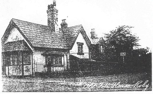
Although of course, all the toll gates are now long gone, there are surviving Toll Gate Lodges, and Roby can boast a fine example. This one, a Grade Two Listed building, and now a private residence, is likely typical of many which existed around that time. Although the site is certainly authentic, there is though, some doubt as to whether the present structure is completely the original. The records indicate that these houses should be:
'not more than five yards in length and four in breadth, built either of brick or stone, according to cheapness, thatched, and with no upper storey.'
It seems fair to assume that the present building is at least contemporary, although it has possibly
been modified and extended. It is built in a 'T' configuration, having a two storey section as the
'T' horizontal (its rear portion, away from the road). The front consists a single storey brick
construction (now rendered), this the vertical of the 'T' configuration, is aligned to the right of
the horizontal. The entire structure clad with a slate roof, with a protruding central brick
chimney stack. The front elevation to Roby Road features a front door and bay window, while
the side elevation for what was Twig Lane features another bay window. This arrangement, at
what was then Roby's highest point, at the crossroads, afforded the Gate-keeper a good view
along both road axis.
Within the immediate area of the Lodge frontage, there was until relatively recently, a sandstone horse trough. No detailed information appears to be available about the origins of this. But it could be worth some speculation and would seem to be reasonable to suppose that the trough might have been installed in the 1700s, around the time of the lodge's construction. The logical purpose would have been to take advantage of the enforced halt and payment of toll, and allow animals to be watered. Very sadly, it would appear that over the course of the last two decades, the artefact was repeatedly vandalised. Eventually it was broken so as to be beyond use or decoration, and removed.
At Roby today, only the Lodge remains as a remnant of the turnpike administration, but it should be pointed out that the roads are still extant in their original layout. Since Viking times, and through the centuries, the Roby crossroad has endured. Even today, although the East/West road and traffic takes prominence, the crossroads still make a valuable contribution to the major network of Liverpool and the surrounding area.
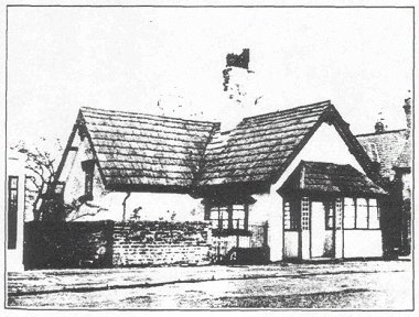
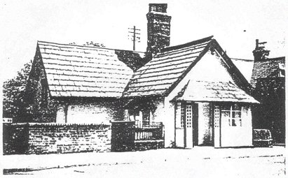
The first two photographs of the Roby Turnpike Lodge are taken from 'The Archive Photographs Series', compiled by Alison Cassidy. The first (top) taken is likely the earliest of the two. The building is extensively covered with ivy - which must have been growing for many years - with no sign apparent sign of any rendering to the walls. Here, we can clearly see the chimney, with its decorative brick structure. The second (below), shows, as the caption indicates, the lodge in 1936. In this picture, the building has been rendered and it would appear this had been applied for some considerable time, the cladding to the chimney stack is clearly weather-beaten and in poor condition. Also apparent is the two storey rear section of the building -bearing in mind the specifications quoted in 'The Minutes of the Trustees of the Turnpike Roads' (already referred to) it indicates alteration some time after original construction in the 1720s.
Two more photographs of the lodge - but taken from a different angle. It is difficult to know which precedes the other, however, the top picture seems to follow in sequence from the photos on the previous page. This one, with the same dark paint scheme, again shows the stack with poor rendering - a photo from 'The Minutes of the Trustees of the Turnpike Roads' it is captioned '1937'. The second photograph, which has been reproduced from Derek Whales' 'Lost Villages of Liverpool', is a much clearer and better quality print, and shows the chimney now without the cladding, and with a different coloured paint finish to the woodwork.
Bibliography
(from Huyton with Roby, A History of two Townships. A.King, Pub. Typebase Ltd. Liverpool 1984)
>
1910 p. 1531)
R. Freethy gives an overview of the scale of Acts passed from 1706, too as late as the 1890s.
(from Turnpikes and Toll Houses of Lancashire. Ron Freethy)
(from Huyton with Roby, A History of two Townships. A.King. Typebase Ltd. Liverpool. 1984)
The particular Turnpike Trust (as the Acts were known) affecting Roby, was created by Act of Parliament, Royal Assent to which was given on April 26th 1726. This was initially for repair of an eight-mile stretch of road between Liverpool and Prescot, and a one-mile branch road along Twig Lane, through Roby to Blacklow Brow in Huyton. The term of the Act was to be for twenty-one years, and it was typically to be administered at local level by a committee of trustees. These were empowered by the legislation to a level equivalent to local justices, who could hold meetings at their discretion.
"This Council, takeing into Consideration that the Road between this Town and Prescott hath been almost unpassable, and that the Inhabitants of this Town have suffer'd much for want of getting their Coales home Dureing the Summer season, thro' the Great Rains that have happen'd in these parts, and that it would be highly necessary to Gett an Act of Parliam't for the Repairing of that Road, so that it may be passable at all times of the year, and for Erecting A turnpike thereon, It is Now Order'd That a Petition to the Parliam't for that purpose be prepared."
It is quite apparent from this text that the prime reason was to bring coal into Liverpool for it's inhabitants' fuel. Winter, or any sustained inclement weather, would evidently soon render the roads - as they existed at that time - to be inoperable. But it wasn't only the road surfacing which was cause for concern, additionally, in many places the road widths were inadequate for the passage of both carriages or heavy waggons - the latter particularly so, in support of the growing trade in wool, cotton, and 'other merchandises' out of, and into the growing port of Liverpool. Turnpike tolls were meant to address these problems.
'The first parts of the new causeway were laid for about thirty yards on each side of the toll-gates. The methods of construction are not described. The materials were "paving stones" (cobbles), "greet stone" (local freestone) and sand. The cart causeway was apparently built alongside the old horse causeway, which was retained as a separate path for horse and foot passengers. No information appears as to whether any means of drainage, additional to the side ditches, were provided.... The entire causeway from Low Hill (Liverpool) .... To Brook Bridge, the boundary of Prescot, was evidently completed before May 1732.' (King, ibid.)
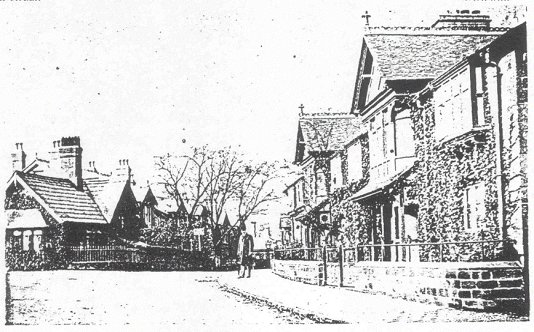
(left)Toll Bar Cottage and Roby Cottages in Edwardian Times.
(left) Toll Bar Cottage, from a postcard posted in Roby in 1936
Roby Toll House (Photographed in 1937)
(left)
Picturesque Toll Bar Cottage, still standing at the junction of Roby Road with Station Road, and the last of Liverpool's toll-bar cottages. It was built in 1726, when toll-collection in Roby began on this former Liverpool-Warrington turnpike.
Frank Green
(30 March 2000)
1. Huyton with Roby. A History of two Townships. A.King
2. Transactions of the Historic Society of Lancashire and Cheshire. Vol.89 (1937)
3. Turnpikes and Toll Houses of Lancashire. RonFreethy
4. Lost Villages of Liverpool - Part Three. Derek Whale
5. The Archive Photographic Series. Alison Cassidy
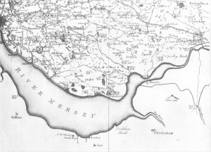
6. A Map of the County of Lancashire, 1786. William Yates